
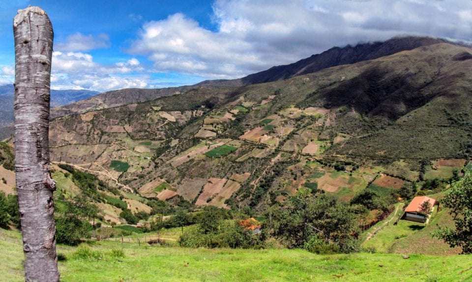
If one day you want to travel and discover the most beautiful landscapes on the planet, then do not hesitate too much and prepare a trip to know the Cordilleras of Colombia. The Andes mountain range is the most spectacular and important mountain chain in Latin America and that divides the Colombian territory into three independent branches: the Western Cordillera, the Central Cordillera and the Eastern Cordillera.
The Cordillera de los Andes enters Colombia through the south-western part of the country and is divided into two chains: The Western Cordillera and the Central Cordillera. The Central Mountain Range divides two branches in the Colombian Massif or Almaguer's Nude, giving rise to the Eastern Mountain Range. The so-called Pacific Ring of Fire is also very popular because it is made up of numerous volcanoes and is found in this region. The Galeras volcano that is located near the city of Pasto and the Nevado del Ruiz which is also a volcano are famous for their recent activity.
What is a mountain range?
Before seeing which are the most important mountain ranges in Colombia, let's explain what is a mountain range.
What difference is there between cordillera, chains or mountain system, or simply mountains ..? Well, I'm going to try to explain it to you. If we go to the dictionary and look for a mountain range, it defines it as: a succession of mountains linked together. In this sense it differs from the sierra in the number of mountains, which is greater in the cordillera. Let's say the mountains are the divisions that we make of the mountain ranges.
How a mountain range is formed
Now if we dig a little deeper, and see it from the geological perspective, I will tell you that mountain ranges are made up of folded areas or in the folding phase. In the elongated areas that are located on the edge of the continents, a large amount of sedimentary materials accumulates, if these undergo significant compression caused by lateral thrusts, they fold and rise, giving rise to the formation of mountain chains. This is how most of the great continental mountain ranges such as the Himalayas in Asia, the Andes in South America or the European Alps have been formed.
This process in movement, which then causes folding can be:
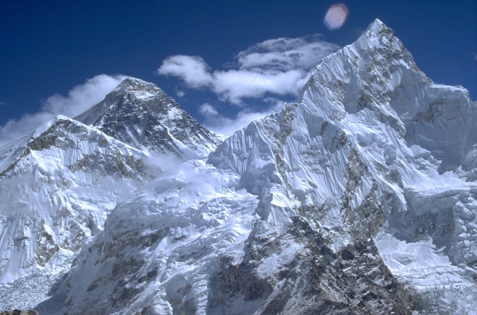
- By collision between two continental plates the lithosphere, The outermost plate of the Earth, which has a variable depth between 10 and 50 kilometers, shortens, folds or breaks and gives rise to mountain ranges (incidentally, this is the same as mountain ranges). Thus the Himalayan mountain range was formed, the highest on the surface. This mountain range extends through several countries: Bhutan, Nepal, China and India and in it we find 10 of the fourteen peaks of more than 8.000 meters high, which are above sea level throughout the planet.
- By collision, but inside two tectonic plates. The Pyrenees are given as an example.
- By collision between an oceanic plate and a continental plate, then the oceanic crust sinks. A typical example is the Andes mountain range, which is the longest mountain range in the world and in it we find the highest volcanoes on the planet.
Atmospheric agents such as water or wind, as well as the vegetation itself and the characteristics of the soil, intervene and shape the mountain ranges. By the way There are not only mountain ranges on Earth, on other planets, such as Mars, there are also, the most famous is the Tharsis.
A curiosity, it is not known which is the oldest mountain on earth, but the tepui or tepui is a class of especially steep plateaus, with vertical walls. It is argued that these types of mountains are the oldest formations, since their origin dates from the Precambrian. But we still do not know much of the seabed surface.
Marine bibs
TI have talked about the mountain ranges that we "see" but there are also mountain ranges in the oceans, they are the so-called marine ridges, which actually form the most extensive mountain system, about 60.000 kilometers in length. These are formed by the displacement of tectonic plates.
The average height of these mountains that are under water is 2.000 to 3.000 meters. These types of mountain ranges have a very rugged relief, with wide slopes and ridges often marked by a deep longitudinal fissure, which is called a sinkhole or rift, in which surface earthquakes and volcanic eruptions occur very often. Through these sediments that accumulate at the edges, the thickness of the volcanic crust is gradually increased.
In some parts of the Atlantic Ocean the ridge moves about 2 centimeters a year, while in the eastern Pacific it moves faster, about 14 centimeters.
Some mountains in these ranges have risen above sea level and have given rise to volcanic islands such as Iceland.
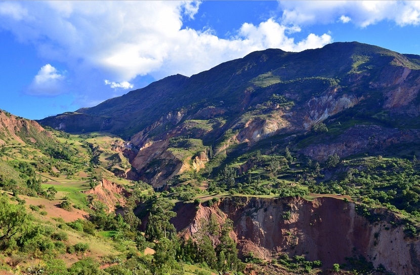
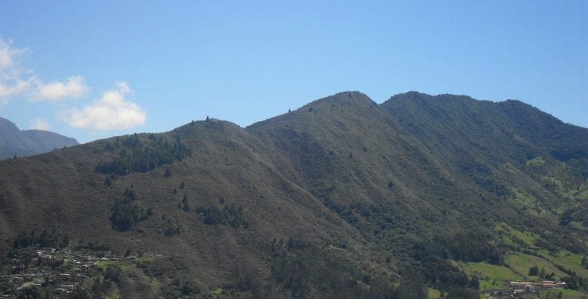
The Cordilleras of Colombia
The Western Cordillera
The Western Cordillera has a length of about 1.200 km and runs north through the country from the Nudo de los Pastos in the department of Nariño in southwestern Colombia to the Nudo de Paramillo in the department of Córdoba, located in the north of the country. .
The highest mountains of the Western Cordillera are –in order of height-:
- Cumbal Volcano: 4.764 meters high.
- Chile volcano: 4.748 m high.
- The Azufral volcano: 4.070 m high.
- Farallones de Cali: from 200 to 4.280 m high.
- Tatamá Hill: 4.200 m high.
- Paramillo massif or Paramillo del Sinú: from 100 to 3.960 m high.
- Munchique Hill: 3.012 m high.
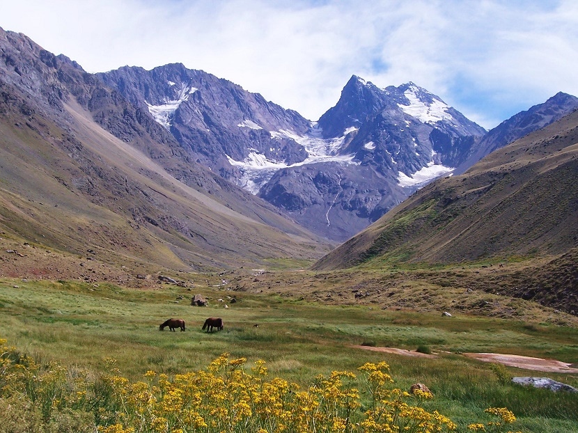
The Central Mountain Range
The central Cordillera extends from the Nudo de Almaguer or Colombian Massif in the department of Cauca to the Serranía de San Lucas de Bolívar in northern Colombia. It is the highest mountain range in the country with peaks over 5.700 meters high and has a length of 1.000 km.
The highest mountains of the Central Cordillera are –in order of height-:
- Nevado del Huila: 5.750 m high.
- Nevado del Ruiz: 5.321 m high.
- Nevado del Tolim: 5.216 m high.
- Nevado de Santa Isabel: 5.150 m high.
- Nevado del Cisne: 4.800 m high.
As you can see, it has really high mountains that seeing them from afar is already impressive because of its large size. They are undoubtedly wonders of nature that Colombia is lucky to have. There are many people who travel to this mountain range with the intention of knowing these mountains and enjoying all their beauty live.
The Eastern Cordillera
The eastern Cordillera is the largest mountain range in the country with a length of no less than 1.200 km. This mountain range extends from the Almaguer knot to the Perijá mountain range, in the department of La Guajira, northeast of Colombia.
The Cordillera is divided into two branches: the Motilones mountain range that extends to the north and the Táchira mountain range that crosses the border between Colombia and Venezuela.
The highest mountains of the Eastern Cordillera are –in order of height-:
- The Sierra Nevada del Cocuy: 5.330 m high.
- The Sumapaz moor: 3.820 m high.
- The Pisba moor: 3.800 m high.
- The Sierra de Perijá: 3.750 m high.
- The Choachí moor: 2.980 m high.
Also in the eastern Cordillera we can find great plateaus, also of great beauty and value for Colombia. They stand out:
- The savannah of Bogotá: 2.600 meters high, where the city of Bogotá is located.
- The Ubaté savanna: 2.570 m high.
- The Sogamoso Valley: 2.570 m high.
Most important land elevations in Colombia
In addition to the Andes Mountains and everything mentioned above, there are elevations of land that are very important for all of Colombia and Latin America that it is a good idea for you to know, in case one day you are interested in traveling to their lands to know these wonders of the world .
Sierra Nevada of Santa Marta
It is found in the coastal plains of the Caribbean. It extends through the departments of Magdalena, Cesar and La Guajira. It has an elevation of 5.775 meters (18.947 feet) above sea level. The highest peak you can find is that of Cristóbal Colón followed by Simón Bolívar. It is the highest mass snow-covered mountain in Colombia. This mountain range has an area of 17.000 square kilometers.
Montes de María or San Jacinto mountain range
It is located between the departments of Bolívar and Sucre in the coastal plains of the Caribbean. It has an elevation of 810 meters.
Serrania de la Macuira
It is located in the Department of La Guajira and has an elevation of 810 meters. It also has an area of 250 square km.
Serrania del Darien
It is located in the department of Chocó. Region of the border between Colombia and Panama. It has an elevation of 1.910 meters on Tacurcuna Hill.
Serranía del Baudo
It is located in the department of Chocó, near the coast of the Pacific Ocean. It is separated from the basins of the Atrato and Baudo rivers and is parallel to the coast with beautiful images of the mountains next to the sea. It has an elevation of 1.810 meters.
Serrania de la Macarena
It is located in the department of Meta, in the southeast of the Eastern Cordillera. It has an elevation of around 2.000 meters. You can discover an area of 625 square kilometers.
Serranía del Perijá or Serranía de los Motilones in the southern area
It is located in Northeast Colombia. It serves as a partial boundary with Venezuela between the departments of La Guajira and Norte de Santander. It has an elevation of 287 meters.
Southeast elevations
They are found in the Eastern Plains. The hills are spread out like Iguaje and Yambi with low plateaus, and the Sierra de Araracuara.
As you can see, the Cordilleras of Colombia have a lot to show the world, and their beauty is hard to beat.
This is reguar, the most important thing is not the economic importance
I think it's crap
The beautiful landscape of our territory shows us how the diversity of the relief offers us places of tourist interest and a diversity of climates that favor crops and natural reserves where diverse flora and fauna are found.
you do not pay but they are located on the map
noooooooooooo that I could not aser
hello how are you
hello friends
hello friends I wish you many congratulations
hello how are you doing jejjejjejjejejjjejje
ha ha ha ha ha ha
very charro
you have to read little books from time to time
very badly they should end this page fools § haha
=(
fool
ALL OF YOU ARE DISRESPECTFUL IF WE LIKE IT ENTOCES LARGENSE Y CALENSE ALMEN IT SERVES US TO SEE THE NATURA LESA OF OUR COUNTRY
Stupid
where is the 4
hahahaha you guys are crazy _________________ »a _ —– ____________ by _ — ______– no ____——– hahaha
hello, don't tell me what I'm looking for, yes, thank you for nothing
I don't care about that, it's filthy
how boring
gross
don't say anything if you don't know
Buuuuuuuuuuuuuuuuuuuuuuuuuuuuuuuuuuuuuuuuuuuuuuuuuuuuuuuuuuuuuuuuuuuuuuuuuuuuuuuuuuuuuuuuu
I did not find anything that answered my question nooooooooooooo
If you serve you are stupid oke the page serves stupid stupid donkeys to all
hello
Well, if you didn't like the page…. well clip ... elsewhere. Why so much vulgarity?…. in addition to a bad spelling, let's be more consistent with what we write….
I think this page is very true everything that says _____________________________________________________________________________________________________________________________________________– and what do you think?
|||||||||||||||||||||||||||||||||||||||||||||||| ||||||||| @
MY MASTER
BUT ZO RELINDOZ ESTOZ PAIZAJEZ
It is the best coffee in the world, Spanish goderos, Africans who are copiones with the brown potatoes and tomato
Please do not put many things because writing is boring and also very tiring please take my desicon
help I need the name of the mountain ranges that have branches
very cool join my feisbook vicky-mueses@hotmail.com
What lack of respect this youth has, well, not all of them are excellent for me.
vacano and chebre this program and all its programs
chebre and draw all your maps that you draw + ´, lñ545444425
IT SEEMS TO ME AN EXCELLENT PAGE EVEN THOUGH THEY ARE ALL SO RUDE ONLY THE PAGE IS MISSING A FEW SETTINGS
Woof! You Are Very Rude This Bn Q 'The Page Is Not Complete But Leave The Rudeness Q' Asquito Uishh '🙂 1 They Do Not Look At Their Tongue And They Are Already Commenting Here
what nonsense
I don't know how to copy 😛
I looked very cool
this is the best here I can find what I want and my famous mountain range is the central one and which is the tulla
I highly recommend this page and I will help you with something if you want to know which is the mountain range with the smallest extension and height is the western one. The one that has the highest heights is the central one. and the widest and most extensive mountain range is the eastern one I hope it has served you mmmmuuuuuccccchhhhiiissssiiiimmmooo
I loved this answer
it's marvelous
that answer in true but I don't like its form
has all the reason and if they are correct answers
You are not bad, he helped me with the note that I wanted
or pull it, serve me
instagram: YELIBETH2402
VERY GOOD
good I iso win an exam in 5.0
we all do it
This is not well written
Help more: pop:
I can help you if you want
the shortest and lowest mountain range is the western one
The landscape is beautiful hahahahahahahahahahaha
😀
I think the text is too long & I don't like it. I prefer other pages. I think they are more summarized & better explained 😉.
I want to thank Catalina Mendoza for not being rude and for helping me, she seems like a great person.
I liked it a lot, I thought it was very cool.