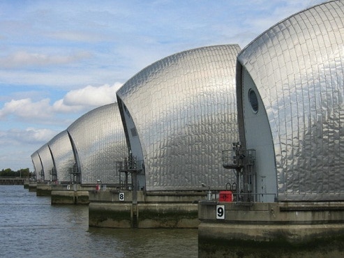
La Thames Barrier It is the world's second largest mobile flood barrier (after the Oosterscheldekering in the Netherlands) and is located downstream from the center of London.
Its purpose is to prevent eventual flooding of the city by exceptionally high tides and storm surges advancing from the sea. It has to be raised (closed) only at high tide, at the ebb it can be lowered to release the water that accumulates behind it.
Its bank is in the north of Silvertown in the London Borough of Newham and its south bank is in the New Charlton area of Charlton in the Royal Borough of Greenwich. Sir Hermann Bondi's report on the North Sea, the 1953 floods affecting parts of the Thames estuary and parts of London was important in the construction of the barrier.
Know that London is vulnerable to flooding. The rising tide is channeled through the North Sea, which narrows towards the English Channel which reaches the Thames estuary. If the storm surge coincides with spring tides, dangerously high water levels can occur in the Thames estuary. This situation combined with the downstream currents in the Thames provides the triggers for flood defense operations.
The story goes that 14 people died in the 1928 Thames flood, and then another 307 people died in the United Kingdom in the North Sea in the 1953 floods.
The Thames Barrier, which crosses the river near Woolwich east of the City of London, opened on May 8, 1984. This technical masterpiece; the largest mobile flood barrier in the world. Nine piers were sunk into the river bed and between them are 10 steel gates. The powerful lifting hydraulic rams take 30 minutes to move the doors into position.
Visits to the royal barrier are not allowed, but there are good views of a river walk. In the visitor center there is a very interesting audio and video program on the construction and operation of the Thames Barrier.
