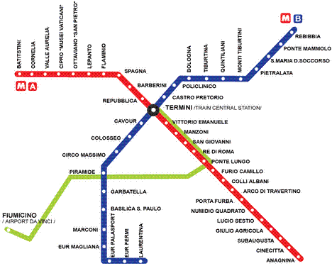
One of the best means of transport for tourists is the metro and Rome is no exception. The Rome subway It consists of 2 suburban lines and a light rail line. It was inaugurated in 1955 and its development was complicated due to bureaucratic problems, which is why it was always behind the Paris or London subways. Not counting the deviations that had to be made when the workers came across archaeological remains.
The second line dates from 1980 and at the beginning of the '90s the underground network was expanded. So we have line A and line B.
- Line A: Cross the city obliquely from northwest to southeast. It has 27 stations and its terminal stations are Battistini and Anagnina. It is orange in color and leaves us at the Trevi Fountain, the Opera House, Cinecitta, Cipro Musei Vaticani, the Spanish Square and other stations near tourist sites.
- Line B: It crosses the city from northwest to south and its terminals are Rebibbia and Laurentina. It has 22 stations, is blue in color and leaves us near the Colosseum, the Basilica San Paolo, Santa María del Soccorso and others.
There are other suburban lines: Rome-Viterbo, Rome-Pantano and Rome-Lido, which are light metro lines that often use the railway line. Mind you, not all stations Rome subway They leave us near the most attractive places in the city and in those cases it is advisable to take a bus. The truth is that buses take longer due to traffic, but they leave us much closer.
Useful information
- Hours: The metro runs between 5:30 and 11.30:12 pm, and on Saturdays until 30:XNUMX pm.
- Price: The daily ticket costs € 1 and you can buy special tickets for several days.
More information - Rome, a surprising city
Source - Wikipedia
Photo - rome.info
