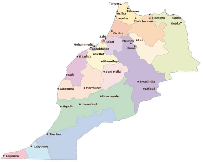
In 1997, Morocco carries out a reform of the territorial administration and the state is divided into a total of 16 regions, of which a regional council, also known as "walí", is in charge. Three of these 16 regions are part of Sáhara OccidentalAlthough it is an area also administered by Morocco, the UN includes them in its list of non-autonomous territories, as if the country were independent.
These 16 regions, in turn, are divided into a total of 45 provinces and 27 prefectures, which are led by a governor. On the other hand, each province and prefecture is divided into districts, municipalities and communes, and when we find a metropolitan area, it is divided into neighborhoods.
Following the administration reform law of 1997, the 16 regions of Morocco, with their capitals, are the following:
1. Chauía-Ouardiga (Settat).
2. Dukala-Abda (Safi).
3. Fez-Boulemane (Fez).
4. Garb-Chrarda-Beni Hsen (Kenitra).
5. Greater Casablanca (Casablanca).
6. Guelmim-Smara (Guelmim).
7. El Aaiún-Bojador-Saguia el Hamra (El Aaiún).
8. Marrakech-Tensif-Al Hauz (Marrakesh).
9. Meknes-Tafilatet (Meknes).
10. The Eastern (Uxda).
11. Rio de Oro-La Güera (Dajla).
12. Rabat-Sale-Zemur-Zaer (Rabat).
13. Sus-Massa-Draa (Agadir).
14. Tadla-Azilal (Beni Mellal).
15. Tangier-Tetouan (Tangier).
16. Taza-Al Hoceima-Taunat (Al Hoceima).
Source - Wikipedia
Photo - Iqraa