
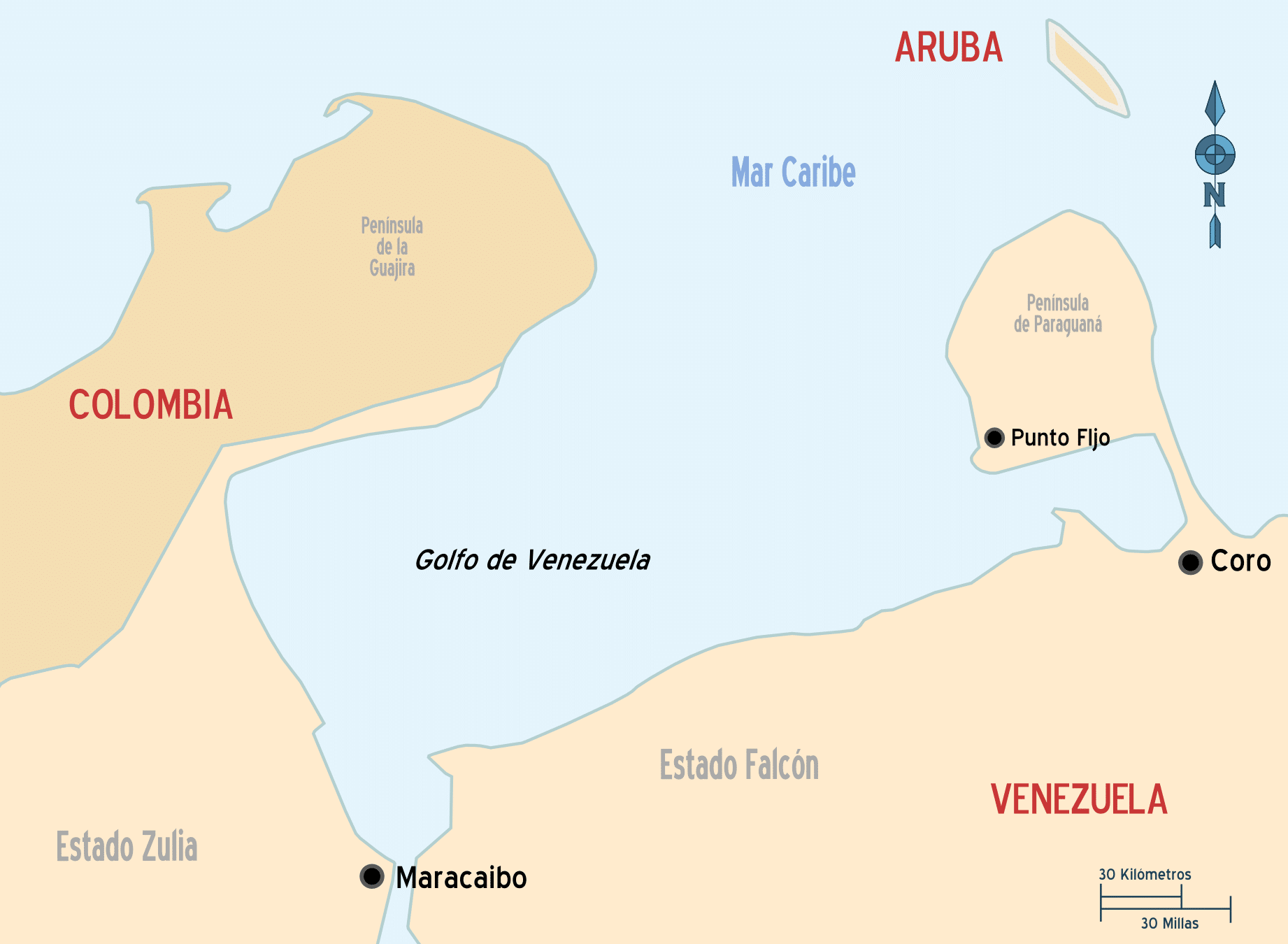
El Gulf of venezuela (or Gulf of Coquivacoa for Colombians) is a body of water located in the north of South America, which in its greater proportion occupies the territorial waters of Venezuela. A small part of the gulf is located off the coast of La Guajira de Colombia, which is why there have been many disputes between both countries as they cannot define the maritime border.
Connected to the Gulf of Maracaibo through a narrow channel, the Gulf of Venezuela is located on the South American plate, just at the limit where it collides with the Caribbean plate. Its depth ranges between 15 and 60 meters.
Exploration and geography of the Gulf of Venezuela
The first exploration expedition in the Gulf of Venezuela dates from the year 1499. The first European to navigate these waters was the Spanish. Alonso ojeda, accompanied by the cartographer John of the Thing and by the Italian navigator Americo vespucio. Two years later the Kings of Spain granted Ojeda a capitulation to settle on the mainland. It was the first time that a colonial settlement was established on the continent, since until then this had only occurred in the islands of the Caribbean.
During the first years of Spanish presence in the region, this area was known as coquivacoa, which probably referred to a local tribe. Already in the seventeenth century, the first documents that speak of the Gulf of Venezuela appear with its current name.
Although there is some controversy in this regard, the word "Venezuela" could have arisen as a result of the presence of indigenous stilt houses on the coasts. These constructions formed a network of canals along the coastline that reminded Europeans of the canals of Venice. These new lands would thus be called "Venezuela", that is, the "little Venice."
Map of the Gulf of Venezuela
The limits of the Gulf of Venezuela are marked by the Guajira Peninsula (Colombia) to the west and Paraguaná Peninsula (Venezuela) to the east. To the north, the Archipelago of the Monks it is considered the natural border between the gulf and the open waters of the Caribbean Sea. To the south, the coasts of the Venezuelan states of Zulia and Falcón. Between them the Maracaibo Canal, which connects the waters of the Gulf with those of the Gulf of Maracaibo, a kind of Venezuelan inland sea.
From east to west, the gulf is 270 kilometers long. The main ports in the area are Maracaibo and Punto Fijo, both in Venezuelan territory.
Oil from the Gulf of Venezuela
The Gulf of Venezuela has great strategic and economic importance. On a strategic level, as it is the connecting route between the Gulf of Maracaibo and the Atlantic Ocean; economically, due to the presence under its seabed of important bags of oil and natural gas.

Amuay refinery, the largest in Venezuela
Venezuela exploits these natural resources, mainly oil. The extraction of crude oil is the main economic activity in the region. Numerous refineries. The largest of these is amuay, which even has its own port and which happens to be the largest refining center in the country. The second most important refinery is called Cardon, located southwest of the Paraguaná peninsula.
The wealth derived from oil is essential to sustain the Venezuelan economy. However, this industry in the Gulf has two negative consequences:
- On the one hand, the environmental deterioration of the region, which translates into the disappearance of numerous coral reefs and the threat of extinction of many of the species that inhabit them, such as sponges and sea turtles.
- Moreover, the territorial conflicts with neighboring Colombia on account of access to natural resources.
Territorial disputes with Colombia
Despite being almost entirely in Venezuelan territory, there is a historical tension between Colombia and Venezuela on account of the sovereignty and control of the gulf. Each of the countries defends its interests with arguments of weight:
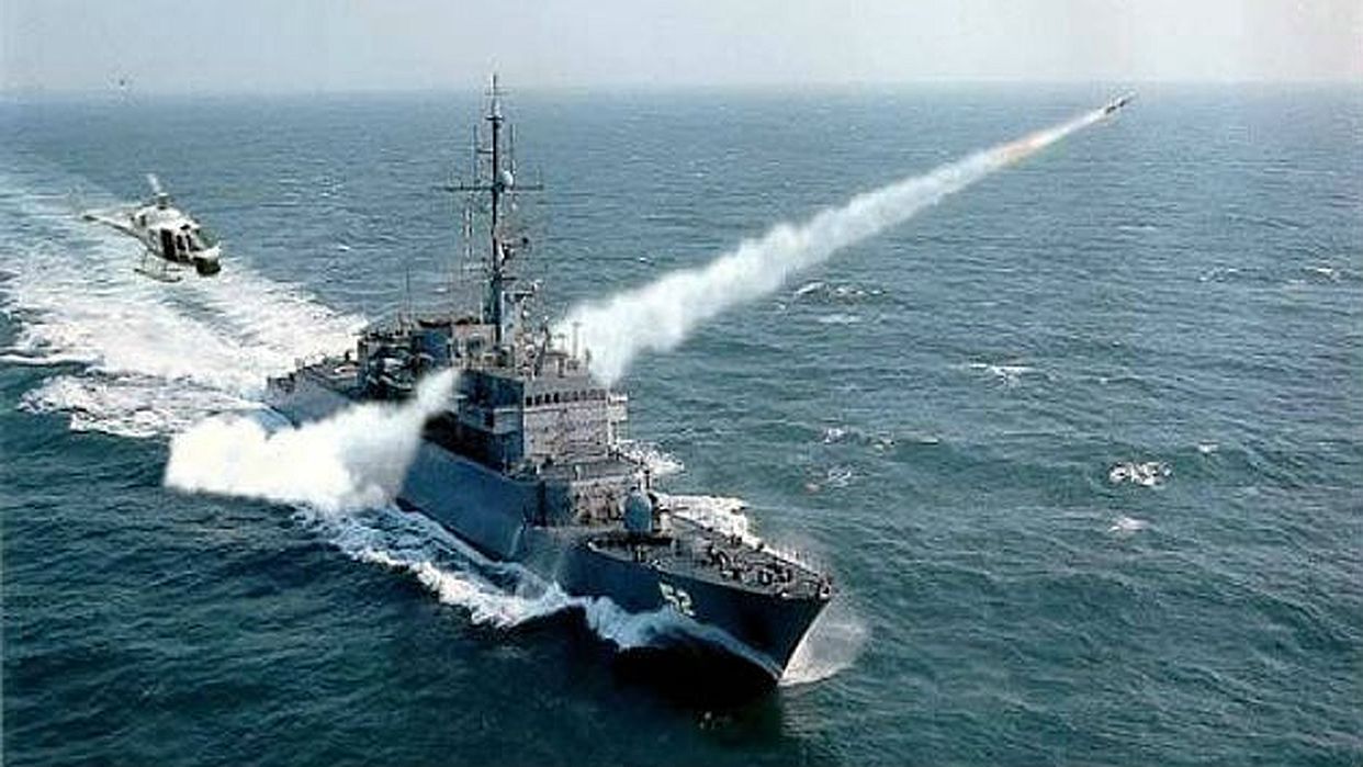
The intrusion of the corvette Caldas in gulf waters caused a serious incident between Colombia and Venezuela in 1987
According to Colombians, the Archipelago of the Monks cannot be taken by Venezuelans as a reference to establish the limit of territorial waters. In this way, Colombia would correspond to a good part of the waters of the Gulf of Venezuela, especially in the northern half. However, Venezuelans affirm that not only is this reference valid, but that they also claim the totality of the internal waters of the Gulf of Venezuela.
Far from being resolved, this disagreement has persisted over time, giving rise to especially tense moments between both countries. The "hottest" episode of this confrontation took place on August 9, 1987. That day the Colombian corvette Caldas entered the gulf, exceeding the limit marked as the border by Venezuela. The crisis threatened to turn into an armed conflict with the mobilization of troops by both parties. Fortunately, he was able to put an end to the war escalation with the return of the corvette to Colombian waters.